Flood Risk Management
You must have certainly heard on the news, at least once a year, that some part of Romania is affected by floods or maybe you have already been even directly affected by floods. Why do floods occur and can they be stopped?



Yearly, floods in Romania have led to the temporary evacuation of hundreds of people, causing damages and economic losses estimated at 140 million Euro. However, floods are a natural phenomenon.
Moreover, thanks to hydrotechnical works currently existing in Romania, as well as to field operational measures, annually, damages amounting to around 1 billion Euro are avoided.
Floods occur especially during spring, while snow is melting or as a result of heavy rainfalls, but, over the recent years, they have occurred all throughout the year and often in successive waves in the same areas. While flooding is mainly a natural phenomenon, changes caused by human activities to the environment, such as excessive urbanization or massive deforestation, economic, industrial, intensive agricultural activities also cause floods more and more often and with increasingly serious consequences.
There are a series of flood risk management measures (prevention, protection of the population and assets, preparation for combating and limiting the flood-generated effects) that we can take. The set of public policies (structural and non-structural measures) adopted by the Romanian responsible authorities encompass the Flood Risk Management.
Are there different types of floods?
Fluvial
Floods can occur when the increase in the levels of water courses causes overflowing. These are called fluvial or „slow” floods (or floods caused by river overflows) and can be caused by sudden snowmelt or heavy rains on extended areas. When the soil cannot fully retain the amount of water resulting from rainfalls cumulated within two or three days over 100 mm, the resulting runoffs are accumulated in rivers overflowing the river channels and exceeding the warning levels (alarm threshold levels, be it for flood or danger).
Flash floods
Torrential rains, storms can cause the so called „flash floods”. They are characterized by large amounts of rainfalls recorded within a short period of time and on a limited area. They can be represented by significant runoffs from slopes, torrents, streams, flash floods on small rivers, with severe local effects, substantial discharge and level increases. Flash floods are some of the strongest negative phenomena occurring with intensity and which, given the atmospheric instability, are difficult to forecast or have a very short warning time.
Groundwater
When water amounts oversaturates the soil and can no longer absorb additional volumes of water. Waters remain longer on the soil surface, causing floods through the phenomenon of water logging, phenomena also related to the insufficient or non-operational water dessication/ drainage systems.
Pluvial
In towns, where the soil has been covered by constructions and concrete, heavy rains may cause the so-called pluvial urban floods. This occurs because the rainwater exceeds at that very time the capacity of sewage systems and the excessive water cannot be absorbed by the soil.
Coastal
Last but not least, there are floods caused by rising of seawater levels, in coastal areas, which occur especially during storms and result in the flooding of the coastal areas during storm surges.
Accidental
Along the years, many hydrotechnical facilities have been put in place for flood protection. When accidents happen (dikes or dams can be damaged or become non-operational), accidental floods occur.
What is flood risk?
In order to be able to take flood preventive and protective measures, first of all, we have to find out what is the probability for them to occur, where they may appear and how extended they might be, as well as what kind of potential damages they may cause.
By the statistical analysis of floods, supplemented by the analysis of historical hydro- meteorological phenomena, specialists determine the statistical distributions of discharges, including characteristic values relevant for calculations, such as maximum discharges with annual exceedance probabilities of 10%, 5%, 2%, 1%, 0.5%, 0.2% or 0.1% for an examined area. Such probabilities associated with characteristic discharges, as well as the water extent and depth (sometimes also the water velocity, in case the area in question is examined by using 2D modeling), define the flood hazard.
The combination of flood hazard with vulnerability (consequences of the respective floods), respectively potential damages caused to the population, assets or socio-economic objectives, as well as to the environment, results in the flood risk.
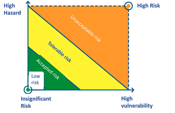
If the probability of occurrence for a major flood is high and may have serious consequences, then we refer to a “high” flood risk.
If the flood probability is low and the consequences are minimum, then the flood risk is “low”.
Regardless of the conditions presented above, there is still the question: what is the risk we are willing or forced to accept? Authorities in the EU Member States, including Romania, develop Flood Risk Management Plans, focusing on areas where the flood risk is significant.
Flood risks have an increasingly higher intensity because of the following factors:
- Land use change – excessive deforestation and intensive agricultural practices, urbanization and economic activities reduce the retention capacity of waters (natural drainage) during and after precipitations.
- Urbanization and real estate developments in flood hazard-prone areas;
- Regularization of natural rivers and disconnection of natural floodplains from water courses which cause the increase in flow velocities and reduction of the natural water retention (reducing the time during which the flood propagates along a given sector – flash flooding;
- Intensification of extreme hydro-meteorological phenomena as a result of climate change linked to uncontrolled urban development.

What is Flood Risk Management?
The Flood Risk Management involves the application of public policies, procedures and practices aimed at identifying, analyzing and assessing flood risks, as well as at monitoring and implementing measures to alleviate the effects of such phenomena.
The highly increasing flood risk requires a more proactive and integrated approach to the Flood Risk Management by combining prevention and preparedness (before) measures with protection and response (during) and, finally, recovery (after) measures.
The integrated flood risk management considers measures for river basin arrangement, in order to increase the water natural retention capacity in the area where flash floods occur and to prevent flooding events. This approach combines structural conventional protective measures with non-structural and green infrastructure-related measures. Such important aspects refer to floodplain management and to the rehabilitation of natural floodplains (the room for the river concept), avoidance of new flood risks and protection of settlements in flood-prone areas through grey and green infrastructure.
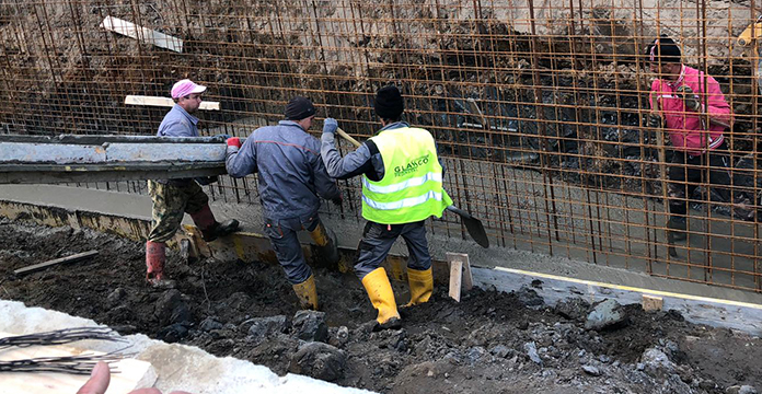
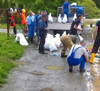
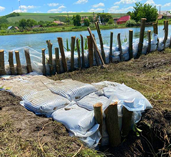
Such measures focused on the flood hazard reduction are supplemented by measures to reduce the exposure through better planning of urban development and proper application of regulations in the constructions field alongside with measures to improve the population’s resilience (for instance constructions/lodgings adapted to resist at a certain water depth, orderly evacuation to prevent life losses, operational interventions for implementation of local measures for protection of buildings by using bags, insurance and aids for post-flood quick recovery, etc.).
Raising awareness and improving preparedness through better monitoring and early warning of the population, as well as by using recovery plans, including affordable social security schemes against floods, all these are strategies to manage the residual risk.
How is the Flood Risk Management achieved?
Following the occurrence, in the early 2000’s, of floods with severe consequences in many countries in the region, the European Commission, in close cooperation with the Member States, developed a policy framework for implementing the Flood Risk Management (FRM) – the EU Floods Directive (FD). The Directive was proposed by the European Commission and adopted in 2007. This is a useful legislative instrument, at European level, which was subsequently implemented in the national legislation of the Member States. Its aim is to identify the most suitable measures, correlated with the implementation costs, in order to reduce and manage risks that floods pose to the population, environment, cultural heritage and economic activity. It requires the Member States, inter alia, to develop Flood Risk Management Plans.
The Directive was transposed into the Romanian legislation in 2007 by adoption of GD no. 846 from 2010 regarding the approval of the National Strategy for Flood Risk Management on the medium and long term.

Important aspects of the Floods Directive include:
- The 6-year planning cycle, with a clearly defined approach, including 3 steps: Preliminary Flood Risk Assessment, the development of flood hazard and risk maps for the areas of potential significant flood risk identified during the preliminary assessment and, finally, the preparation of FRMP 1 and of associated Programs of Measures;
- River Basins as the units of flood risk management, incorporating the IWRM principles (Integrated Water Resources Management);
- Active Stakeholder Engagement and organization of public consultation;
- Flexibility in the application of FRMP;
- Focus on nature-based solutions and green infrastructures;
- Adaptation to Climate Change;
- Coordination of measures and international cooperation;
- Alignment with the Water Framework Directive (WFD) and with other environmental directives.
Romania has completed the first cycle for implementation of the Flood Directive and is currently in the second cycle of implementation, respectively stages two and three, of updating Flood Hazard and Risk Maps, as well as Flood Risk Management Plans.
 Weather Warnings
