Implementation of the Floods Directive Cycle 1
Floods are a major threat in many areas of the world. In the EU, Romania ranks fourth in the flood risk related classification, right after Poland, Slovakia and the Czech Republic.


Floods are a major threat in many areas of the world. In the EU, Romania ranks fourth in the flood risk related classification, right after Poland, Slovakia and the Czech Republic. As a Member State, Romania is implementing the provisions of the EU Floods Directive.
This Directive requires the Member States to follow a series of steps in order to identify and manage the flood risk according to international standards and best practices. Results of the stages defined in the Directive are finally included in the Flood Risk Management Plans (FRMPs). In Romania, these are 12, one for each watershed area defined by the 11 River Basin Administrations and a 12th for the Danube River.
2015 – 2021
The first implementation cycle of the Directive
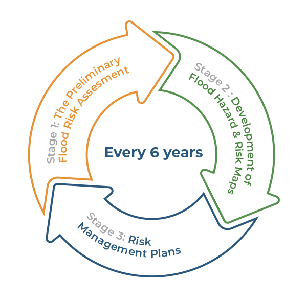
Romania completed the first cycle for the development of Flood Risk Management Plans at the end of 2015. The Floods Directive implementation follows three stages.
The first stage refers to a Preliminary Flood Risk Assessment (PFRA) by which all water courses, coastal areas, urban areas prone to the risk of floods from pluvial sources and areas with a risk of floods from underground waters are assessed in terms of flood occurrence probability. The aim of this assessment is to identify Areas of Potential Significant Flood Risk (APSFRs).


12 Flood Risk Management Plans
Once the APSFRs are identified, a second stage is to develop Flood Hazard and Risk Maps for each of these areas.
The third and last stage refers to the preparation of Flood Risk Management Plans (FRMPs) for each of the 11 River Basin Administrations, plus the Danube River. Consequently, 12 FRMPs will be prepared to also include Programs of Measures in order to mitigate the flood risk.
These stages make up the implementation cycle which is repeated every six years.
The Preliminary Flood Risk Assessment
The Preliminary Flood Risk Assessment (PFRA) was conducted during the first cycle for implementation of the Floods Directive, by two key approaches:
The historical analysis of floods
Based on a methodology and certain criteria developed by MEWF, ANAR and INHGA, previous significant floods have been identified.
The analysis of previous flood management projects
Areas of potential significant flood risk have been identified by combining the historical analysis with an analysis of previous flood risk management and hydrotechnical works-related projects.

12 PFRA reports
The first stage of the cycle for implementation of the Floods Directive has resulted in 12 PFRA reports.
First cycle of implementation – Flood Hazard and Risk Maps
Hazard refers to the possibility for floods to occur, while the Risk involves the estimated adverse impact on the population, property, environment, cultural and economic heritage. Both are represented by means of maps.
Hazard maps are prepared by using hydraulic modeling techniques and show the depth and extension of the water surface in the case of different flood scenarios, from extremely serious floods, with a low probability of occurrence, to low intensity floods, with higher probabilities of occurrence.
Based on hazard maps, risk maps are prepared, indicating the damages likely to be caused by different flood scenarios, as well as the prejudice to human life, property, environment, cultural and economic heritage.
Flood Risk Management Plans
Flood Risk Management Plans are comprehensive documents aimed at a strategic guidance of the work of authorities in managing floods. Plans should include:
- Conclusions of the Preliminary Flood Risk Assessment
- Objectives related to the flood risk management
- Flood Hazard and Risk Maps
- Programs of Measures and their prioritization
- Plan for monitoring the implementation of measures
- Activities for engaging stakeholders
- List of competent authorities in the FRMP implementation, monitoring and evaluation.

The core element of the plans is the Program of Measures. It can include structural measures and/or non-structural measures.
Structural measures can be „grey infrastructure” related measures, such as dams, dikes and other such constructions for the protection against and alleviation of the flood effects, or ”green infrastructure”-related measures. The latest are also called nature-based measures. Examples refer to the restoration of river floodplains and channels, restoration of meanders, wetlands, afforestation and other works aimed at preventing the formation of torrents and the soil erosion.
Non-structural measures have no direct protection role, but a role of prevention, preparedness and response to floods. Examples include the land use regulations or early warning or alarming systems.
The full version of the plans under the 1st implementation cycle of the Floods Directive can be consulted here.
 Weather Warnings
